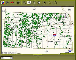
KansasWildlife.com
This RouteMap application was developed for KansasWildlife.com for assisting hunters in locating Walk In Hunting Areas (WIHA) in the state of Kansas.
With this on-line mapping capability, You can locate a walk-in hunting area by typing your address with a specific search radius or pan and zoom to the area of your choice. You can also request driving directions to the Walk In Hunting Area of you choice.
It's that easy!
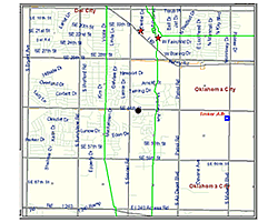
One Call Application Third Party Damage Prevention
One Call is a State mandated system created for the prevention
of damage to underground facilities. All companies operating underground
assets are required to become a member of their state's One Call System.
Members must create and manage a database and/or maps of asset location
information (pipeline centerlines) and submit it to the State system,
where it is combined with other asset owner data.
GISEDGE developed this application to reduce the cost of processing Locate
Requests. It does this by combining local knowledge with accurate centerline,
parcel, and road data, the four components fundamental to the integrity
of the system.