| |
|
|
|
|
| |
|
ArcGIS 3D Analyst |
|
|
| |
|
|
|
|
| |
|
Software Overview: |
|
|
| |
|
|
|
|
| |
|
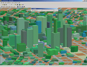
ArcGIS 3D Analyst enables users to effectively visualize and analyze surface data. Using 3D Analyst, you can view a surface from multiple viewpoints, query a surface, determine what is visible from a chosen location on a surface, and create a realistic perspective image draping raster and vector data over a surface. |
|
|
| |
|
|
|
|
| |
|
The core of the 3D Analyst extension is the ArcScene application. ArcScene provides the interface for viewing multiple layers of three-dimensional data and for creating and analyzing surfaces. |
|
|
| |
|
|
|
|
| |
|
ArcGIS 3D Analyst provides a suite of methods for interactive perspective viewing and advanced tools for three-dimensional modeling and analysis applications. ArcGIS 3D Analyst is integrated into the ArcGIS Desktop to allow you to create dynamic and interactive maps that will elevate your geographic visualization and analysis. |
|
|
| |
|
|
|
|
| |
|
|
|
|
|
| |
|
|
|
|
| |
|
|
|
|
| |
|
ArcGIS 3D Analyst |
|
|
| |
|
|
|
|
| |
|
Contact GISEDGE
at (616) 485-3414 for pricing and ordering |
|
|
| |
|
|
|
|
| |
|
|
|
|
| |
|
|
|
|
|